Are you interested in using satellite imagery for remote sensing applications? We’re excited to share access for Medium users to an interactive demonstration of simulated imagery generation based on the real-life VENuS (Vegetation and Environment monitoring on a New MicroSatellite) mission (a collaboration between CNES and ISA).
Now available in the Rendered.ai PaaS Sample Gallery, this workspace simulates vegetation and environmental monitoring data captured by the VENuS mission’s super-spectral microsatellite platform. You can customize the simulation by adjusting parameters such as season, visibility, and surface reflectance, making it ideal for:
- Developing and testing computer vision algorithms for remote sensing data analysis
- Exploring data processing workflows using synthetic data
Getting Started
To access Rendered.ai’s VENuS Satellite Sensor workspace:
-
- Sign up for a no-commitment, free trial of the Rendered.ai platform.
- After logging into the platform, visit the Sample Gallery, look for the “VENuS Satellite Sensor” workspace, and click the “Create Workspace” prompt.
- For more information on using organizations, workspaces, graphs, and datasets in the Rendered.ai platform, visit https://support.rendered.ai/rd/.
About This DIRSIG
This demonstration was created using our capability to containerize simulation models into synthetic data channels for our cloud platform. In this case, we reconfigured existing implementation around the Rochester Institute of Technology DIRS Laboratory’s DIRSIG simulator.

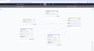
A graph showing how to configure a basic industrial scene with Rendered.ai and DIRSIG.
DIRSIG is a physically accurate simulation system for remote sensing imagery across a broad section of the detectable electromagnetic spectrum. DIRSIG works with 3D-modeled environments with scientifically profiled materials to generate accurate spectral ‘reflections.’
Through work with Rendered.ai, DIRSIG has been enhanced to handle sophisticated satellite and drone vehicle movement patterns. DIRSIG channels also work with atmospheric models built with MODTRAN from Spectral Sciences, which can be provided by a subscriber or built by the Rendered.ai Customer Success team.

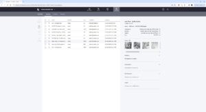
Sample datasets provided with the “VENuS Satellite Sensor” workspace.
Learn More About the VENuS Mission
- European Space Agency (ESA) Overview
- The Centre National d’Etudes Spatiales (CNES) Website
Chat with a Rendered.ai Synthetic Data Expert: Share your ideas for new demo simulations, discuss your current challenges with training computer vision algorithms, and assess how the Rendered.ai PaaS can boost the productivity of your AI/ML systems anytime!


