
Nathan Kundtz, CEO of Rendered.ai, recently shared his thoughts in Engineers Outlook Magazine about the state of geospatial engineering for the aerospace and satellite domains, new challenges arising with new types of advanced sensors, and the critical role of well-informed AI in the future of effective geospatial analysis.
Here are the highlights:
- Geospatial engineering is experiencing a transformative moment, enabled by unprecedented accessibility to space, emerging complex sensor technologies and a vibrant network of specialized suppliers.
- Geospatial technologies are no longer just tools to inform matters of military defense. Satellite data now supports decisions across industries and governments in near real-time, with wide-ranging impact for climate action, disaster response, food security, insurance and finance, and public health and safety.
- Walled and prohibitively expensive training data makes synthetic data generation increasingly more necessary to quickly training and updating geospatial AI systems to extract reliable insights from today and tomorrow’s sophisticated sensors.
- Lowered barriers to entry in the space domain has increased the number of satellites collecting geospatial intelligence launched by private companies, such as SpaceX and Rocket Lab by over 700% in just the last 10 years.
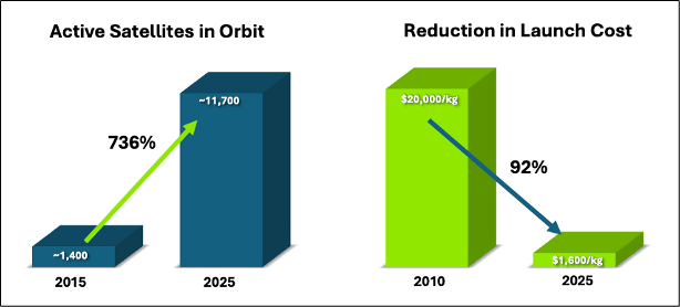
Key Trends in Space Accessibility
- As satellite hardware democratizes, sensor technology onboard has advanced, and complex, high-dimensional data collection (e.g., Synthetic Aperture Radar, hyperspectral, and infrared imagery) has skyrocketed. By 2025, commercial providers like Planet, Satellogic, ICEYE, and others are collectively generating hundreds of terabytes per day.
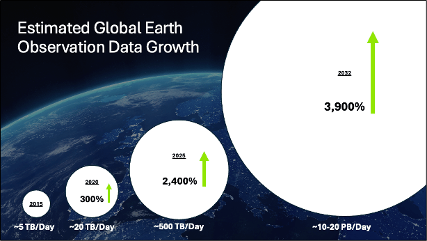
Data Growth in Earth Observation
- All of this geospatial data cannot be realistically analyzed without AI models to identify subtle patterns and generating actionable insights quickly, which rely on ample and diverse training data – often costly limited, or impractical to acquire.
- Integrating AI and synthetic data significantly enhances geospatial solutions’ accuracy, scalability, and robustness, transforming complex sensor data into clear, actionable intelligence in less time.
Read the full article at engineersoutlook.com.
Nathan Kundtz Biography:
Dr. Nathan Kundtz has a PhD in Physics and an MS in Electrical Engineering from Duke University. Nathan’s research has covered diverse topics in Electromagnetic modeling and design, superconductivity, and semiconductor devices. Nathan has authored or co-authored more than 40 patents and patent applications and over 30 peer-reviewed publications, including award-winning doctoral research. LinkedIn has recognized Dr. Kundtz as one of the top 10 technology professionals under 40, is one of Goldman Sachs’ 100 most intriguing entrepreneurs, Puget Sound 40 under 40, and has been inducted into the Duke Graduate School’s Few-Glasson Society.

